Labor Day with my sisters and Carolyn is becoming a tradition now. Last year we visited Zion NP, this year we visited Bryce Canyon NP. To be honest, Bryce didn’t seem too exciting for me. The day hike lists, from easy to strenuous, seemed like hikes to a viewpoint. I checked Google Maps and realized that one destination on my list was only an hour’s drive away- Lower Calf Creek Falls. Our trip now included an extra detour on HWY 12. We decided, the night before our trip, to include Angel’s Landing before we return home. After reviewing trails our finalized plan was to hike Mossy Cave, Lower Calf Creek Falls, Navajo Trail, Fairyland Loop, and Angel’s Landing.
We left Friday night around 9pm and booked it to Utah. It felt great driving the Frontier again even though she isn’t as strong as before. We arrived in Panguich at 10am just as the low-gas light went on. Bryce Canyon was half an hour away and the trailhead to Lower Calf Creek Falls an additional hour.
The drive on the 12 is really beautiful. You’re welcomed with red soil and peaking hoodoos. Our first stop was Mossy Cave Trail. This was a nice break after 12hrs on the road. The trail is only 1mi round trip. The trail is easy. You cross to bridges, the second of which provides a nice view of the waterfall. After about a quarter mile there is a fork- the right leads the top of the waterfall and the left to the viewpoint of the mossy cave. Though there isn’t much shade, the running creek makes trail cool. This is a nice little stop if it is in your way, otherwise I would skip it.


Next stop was to Lower Calf Creek Falls. The drive on the 12 is so beautiful that I wish I was the passenger. There are multiple pull-offs so one can admire the views. Sections of the 12 winds through up and down the mountain so it can get a bit sketchy if the driver isn’t attentive. It’s a an amazing drive though. I’d definitely take a detour on the 12 any opportunity I get.

We arrived at the Calf Creek Recreational entrance and were told that the parking lot and campground was full. Parking is $10 and initially we had to park next to the highway. Luckily two cars were leaving and the attendants redirected us to the open parking spot. From the parking lot, the trail to Lower Calf Creek Falls is 6mi roundtrip. The actual trailhead is a little under a quarter mile from the parking lot, so I included that in the total mileage.
The hike is really beautiful. Initially I felt that the trail was a bit “touristy” since you can see the 12 on the hike. However the highway disappears quietly behind the mountain. You hike fairly close to the creek and are always surrounded by huge cliffs throughout the hike. You can see where the snow/rain runoffs after they melt. Despite the the cliffs around you, the hike barely provides any shade until you are near the waterfall. You go through tall bushes and reeds along the path. Elevation change isn’t drastic. The waterfall roars behind a few trees. And finally you are greeted with Lower Calf Creek Falls. It is 130ft high and the background is covered in beautiful green moss. We spent about an hour here to play in the water and eat. The breezed the return hike after the swim.


After Lower Calf Creek Falls we had to book it to Bryce. It was an hour and a half drive and the sun was beginning to set. Our initial reaction to Bryce Canyon city was that it was gimmicky. They definitely cater to the tourists. Our group doesn’t like being around large group of people so we wanted a secluded site. Thankfully Dixie NF is literally next to Bryce NP. We drove on FR 090 for about two miles and found a site. We drove by a couple campers who had the same idea but we never saw anyone near our site- success! Setting up camp was funny because my Yvezee forgot to bring the tent for her and Yvette. So we had to drive back to town and pick up a tarp for them to sleep under. I wanted to hike Navajo Trail in Bryce NP, but it was getting dark and everyone looked exhausted and hungry. I was lowkey disappointed but I knew we needed energy for the next day.

We woke up much later than I wanted on Sunday to hike Fairyland Loop. We started at 10am. We started the “opposite”- going right instead of left in the beginning- way of the standard loop because we didn’t want to have a constant incline as the last leg. You’re welcomed with a vast view of hoodoos shaped next to mountains. This portion of the trail is also the Rim Trail. We reached a fork that detours to Sunrise Point, but I turned away because I could see and hear the massive crowd. From this fork you begin a long trek down into the canyon. You see pinkish hills that look like Carolyn’s palettes. There are a lot of photo opportunities walking next to the Himalayan salt-colored hoodoos. Further down is a detour to Tower Bridge, which is about the half-way point of the trail. This is a perfect spot to take a lunch break. From here is another incline with spectacular views of the other side of Fairyland Canyon. You can view the aptly named Sinking Ship, which is a rock formation that looks like a sinking ship. My knees were aching at this point. You go down the canyon once more through a little forest until the last mile. I was tired and really wanted to end the hike at this point. Switchback after switchback after switchback you go back up and gradually return to the parking lot. We finished in just under 5hrs, not counting our lunch break.


The night before we decided to go to Willis Creek Canyon after Fairyland Loop since we weren’t too fond of staying with the crowds in Bryce NP. Onward back on the 12, this time only stopping to Cannonville, 20 minutes away. We stopped by the BLM Visitor Center only to see we just missed it (it closes at 430pm, we got there at 445pm). In retrospect, getting to the trailhead was fairly easy but during the drive there I had my doubts. From Cannonville you go south, turn right on BLM 500 and drive 6mi that dirt path. I had my Frontier and she had to work to get up them mountains. There are a couple river crossing with big dips, I don’t think a regular sedan would have an easy time getting to the trailhead. The parking lot was all SUVs and trucks. We descended down to the creek and walked downriver to the slot canyon. We saw about ten hikers leaving and didn’t see anyone else during our hike- perfect. The hike is easy the slot canyons are beautifully carved. The creek is really shallow. At one point there is a little 12ft waterfall that you’d have to go around. The slot canyons become surprisingly tall. It isn’t as majestic as the Narrows, but I was still in awe. We turned back after 1mi because the sun was setting.


Hiking Angel’s Landing was the next on our list and we were an hour and a half away. We drove to Mt Carmel Junction and found a spot in BLM land next to the 9. We arrived at 9pm and KO’d immediately. We woke up right before sunrise and didn’t get to Zion NP until 7am. We reached the trailhead and started hiking at 740am.
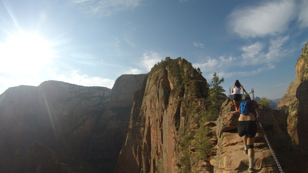
Angel’s Landing was filled with hikers. There was never a moment that I felt secluded. That is the main why I think this hike is overrated. From the trailhead you walk next to the Virgin River and is fully exposed. You reach Walter’s Wiggles and here is when majority of hikers will realize Angel’s Landing isn’t an easy hike. After the switchback you go into the canyon and walk up a few more switchback until Scout’s Lookout. A lot of people were resting here and we overheard a few people saying this is their stop. The last .5mi is what makes Angel’s Landing the icon that it is. The walk to the viewpoint is nerve wrecking. You are literally walking on the edge of a cliff on both sides. Since the trail is narrow you will need to be careful and coordinate with opposing traffic. It took us another hour to reach the end from Scout’s Lookout. The view is rewarding- you can see the valley on one side and an imposing mountain on the other. Unlike the other hikes, the return hike to Scout’s Lookout took much longer. This was because it was 11am when we returned and much more people were hiking. Additionally, we heard a hiker passed out and cut her head on the way up. We passed her and she was ok. Definitely start this hike early to avoid traffic jam.


The drive back to San Diego was much longer than expected simply because I forgot about the fact that EVERYONE from SoCal was returning from their Labor Day trips. We were stuck in Prim Valley for an hour and had another hour of congestion near Barstow. Gahh. It was all worth it though. I will definitely write reviews of each trail at some point with more pictures.
SIDENOTE: Goodness. Blogging is DIFFICULT. I haven’t even started writing about our Oregon Eclipse experience back in August. Shout out to all the writers that are able to churn out a post immediately after a trip. I didn’t know writer’s block happened even if writing a review.

Leave a comment